Seismic software
Seismic software
              Velocity Modeling
              Attribute analysis
              Geological modeling
              Reservoir characterization
              Seismic mis-tie
              Petrophysics
              Seismic Interpretation Software
              Geological interpretation
              Well tie
              Horizon Picking
              Fault picking
            Velocity Modeling
- Layered constant velocity model
 - Velocity modeling using checkshots/horizons/markers
 - Velocity modeling using RMS velocity
 - Depth conversion
 - Velocity model QC – pine chart
 - Integration of checkshots, markers and horizons for calibration
 - Adding surface as a trend
 - 2D and 3D velocity model visualization
 - Incorporation of fault data
 
            Attribute analysis
- Wide range of dynamic and structural attributes (e.g., amplitude, phase, frequency, coherency)
 - Attribute extraction along horizons or mapping in windows
 - 3D attribute volume generation and slicing
 - Attribute co-rendering
 - Spectral decomposition
 - AVO attribute computation (e.g., intercept, gradient, fluid factor)
 - Advanced 3D pre-stack gathers view
 - AVO cross-plotting and analysis
 - Pre-stack data conditioning for AVO analysis
 - AGC, gain and filtering (stacks and gathers)
 - Multicore calculations
 
            Geological modeling
- Concept geological model
 - Layered geological model construction
 - Integration of well logs, seismic data and outcrop data
 - Fault and horizon modeling
 - 3D geological model visualization
 - Lithofacies and petrophysical property modeling
 - Incorporation of geological trends and surfaces
 - Reservoir characterization
 - Cross-section and map view generation
 - Creation of maps from markers
 - Advanced map editor
 
            Reservoir characterization
- Detailed lithofacies and petrophysical property modeling
 - Reservoir volumetrics and reserves estimation
 - Gross rock volume calculation
 - Oil and gas in place calculation
 - Geobody creation from gross rock volume
 
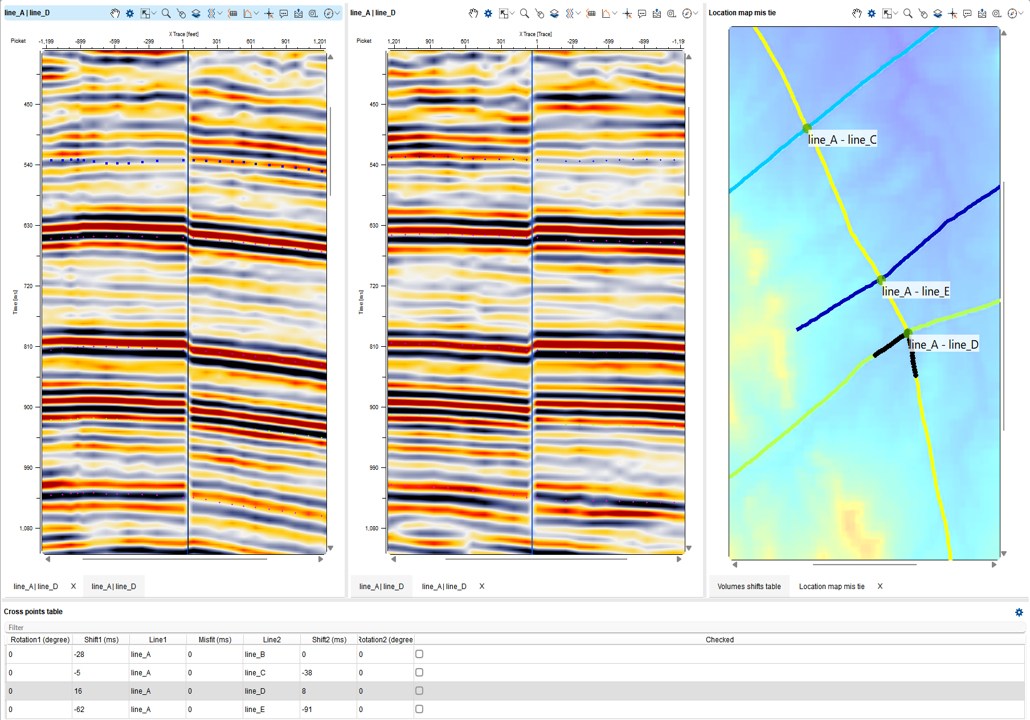
            Seismic mis-tie
- Visualization at different intersections
 - Detailed mis-tie table
 - Phase rotation
 - Constant and variable time corrections
 - Visualization of corrections on the map
 - Interactive manual adjustment
 - Automatic calculation and applying of mis-ties
 - Automatic calculation for phase and time shifts
 - Automatic corrections for large datasets
 - Export tied data
 
            Petrophysics
- Automated Curve Classification
 - Histograms
 - Log Normalization
 - Cross-Plots with Equations
 - Curve Calculator
 - Interactive Interval Selection
 - Curve Editing within Intervals
 - Depth Shifting
 - Continuous/Discrete/Cumulative Visualization
 - Interpretation Tools (Available Soon)
 
            Seismic Interpretation Software
- Geological Interpretation
 - Well-Tie
 - Horizon Picking
 - Fault Picking
 - Velocity Modeling
 - Attribute Analysis
 - Geological Modeling
 - Reservoir Characterization
 - Petrophysics
 - Seismic mis-tie
 
            Geological interpretation
- Well arbitrary line visualization
 - Linear/log/discrete log visualization
 - Numerous tracks per well
 - Interactive picking of markers
 - Handling thousands of wells
 - International stratigraphy colors
 - Templates for well log visualization
 - Well log calculator
 - Flattening to marker or datum
 - Synchronized zoom/scroll along all wells
 - Well logs ghost view
 - Constant/relative distance between wells
 
            Well tie
- Synthetic generation
 - Reflection coefficient computation with sonic or sonic and density logs
 - Wavelet analysis with manual settings
 - Wavelet detection from data
 - Cross correlation analysis between synthetic and seismic trace
 - Interactive tie points setting
 - Stretching and squeezing of the synthetic trace
 - Velocity change analysis
 - Auto-fit synthetic to real trace
 
            Horizon Picking
- Dynamic synchronization between all views
 - Simultaneous horizons interpretation on 2D, 3D or arbitrary line view
 - Interactive picking in time or depth domains
 - Magnetizing to maximum or minimum values
 - Automatic picking for 2D or 3D
 - Import/export horizons in ASCII and other formats
 - Integration of horizons with markers
 - Horizon amplitude and attribute extraction
 - Horizon map creation and easy updating
 - Flattening to any horizon
 - Seismic ghost view
 - Intelligent seismic mis-tie workflow
 - Built-in stratigraphic time scale
 - 2D/3D arbitrary line visualization
 
            Fault picking
- Picking fault in any projection: 2D/3D/Slice/Horizon
 - Picking fault sticks
 - Assigning/re-assigning fault sticks to any fault
 - Fault editing and merging
 - Automatic fault type and direction visualization
 - Incorporating faults into map creation
 - Incorporating faults into velocity and geological modeling
 - Creating faults from polygons
 - Using attributes for fault interpretation (variance, coherency, etc.)
 - Fault import/export